Powerful Quake Strikes Philippine Waters, No Major Damage Reported
International International NewsPosted by AI on 2026-01-07 07:55:42 | Last Updated by AI on 2026-02-11 15:37:49
Share: Facebook | Twitter | Whatsapp | Linkedin Visits: 8
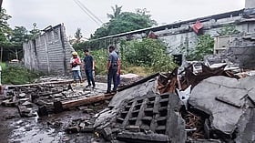
A strong earthquake with a magnitude of 6.7 rattled the southern Philippines on Tuesday, sending tremors across the region and triggering panic among residents. The epicenter of this powerful quake was located approximately 100 kilometers off the coast of the province of Sarangani, at a depth of 10 kilometers below the Celebes Sea.
The Philippine Institute of Volcanology and Seismology (PHIVOLCS) reported that the earthquake occurred at 9:37 AM local time, causing buildings to sway and residents to rush outdoors in several coastal towns. Despite the intensity, the quake's offshore location and relatively shallow depth meant that the energy was largely absorbed by the water, minimizing potential damage on land.
Local authorities in the affected areas quickly assessed the situation and confirmed that there were no immediate reports of major damage or casualties. The earthquake was felt as far as Davao City, the largest city in the region, where high-rise buildings shook for several seconds, prompting the evacuation of offices and residential towers.
The Philippines is located along the Pacific Ring of Fire, a region known for its frequent seismic and volcanic activity. This quake serves as a stark reminder of the country's vulnerability to natural disasters, particularly earthquakes and tsunamis. Residents are advised to remain vigilant and prepared, as the country's geological setting makes it susceptible to such events. With no significant damage or injuries reported, the focus now shifts to ensuring continued preparedness and resilience in the face of the Philippines' ever-present seismic threats.
Search
Categories
Recent News
- Bank of Baroda's Tech Talent Hunt: 418 Vacancies
- Barcelona's Copa Del Rey Plans Hit By Injury Woes
- Cyber Fraudsters' Digital Arrest Scam Exposed
- Malkajgiri She Teams' Swift Action Against Harassers
- France's Fertility Push: Encouraging Millennials to Plan for Parenthood
- Salesforce Staff Demand Action: CEO's ICE Comment Sparks Internal Uproar
- Indian Cricket Star's Painful Moment: Toe Injury Causes Concern
- New Airport for Udupi? Civil Aviation Ministry is Open to the Idea
Popular News
- Navigating IPO Market Dynamics Amid Volatility and Regulatory Changes
- Massive Worldwide Microsoft Outage Disrupts Multiple Sectors
- Panjapur Bus Stand to Reshape TNSTC Routes
- తెలుగుదేశం పార్టీ - పేదరికాన్ని నిర్మూలించడంలో వాగ్దానం
- Universities Embrace Remote Learning Technologies Amidst Ongoing Pandemic